New Zealand's Satellite Coverage Map Explained
Explore New Zealand's complete satellite coverage map. Understand how services like Starlink provide internet to rural and remote areas. Get connected today.
When you look at a map of New Zealand, the connectivity challenge is immediately obvious. We’re a country of rugged mountains, remote coastlines, and sprawling rural areas where standard internet and mobile signals just can’t reach. This is where a satellite coverage map becomes an incredibly important tool.
Think of it less like a typical road map and more like a blueprint of connectivity from the sky. It shows you exactly where satellite signals can deliver communication services, filling in the gaps left by traditional infrastructure.
Why Satellite Coverage Maps Matter in New Zealand
For anyone living, working, or even just adventuring outside of New Zealand's main urban hubs, a reliable connection isn't a luxury—it's often a lifeline. The same stunning geography that makes our country so special also makes building cell towers everywhere impractical, if not impossible. This creates huge "not-spots" where communication simply vanishes.
A satellite coverage map is the direct answer to this problem. It's a visual guide to a satellite's "footprint," which is the specific patch of Earth where its signal is strong enough to use. For a farmer in a remote Southland valley or a tramper deep in Te Urewera, this map can mean the difference between staying connected and being completely cut off.
Bridging the Connectivity Divide
The need for this technology couldn't be clearer. Roughly 40% of New Zealand's landmass has no traditional mobile coverage, a gap that creates serious hurdles for safety, business, and day-to-day life.
But things are changing fast. In 2024, One NZ started rolling out a nationwide Satellite TXT service using Starlink's Direct to Cell technology. The goal is to cover the entire country and extend about 20 kilometres offshore. This system essentially turns satellites into "cell towers in the sky," a game-changing capability that proved its worth during the Cyclone Gabrielle emergency response. You can read more about how this satellite integration is ending the 'off-the-grid' problem on The Spinoff.
This visual from Starlink's interactive map really brings the progress to life, showing its extensive availability across New Zealand.
The solid blue colouring over both the North and South Islands tells a powerful story: high-speed, low-latency internet is now a real option for almost every Kiwi household and business, no matter how far off the beaten track they are.
Practical Applications Across Aotearoa
Knowing how to read a satellite coverage map has direct, real-world benefits. It helps you answer crucial questions before you invest in new tech or head into the backcountry.
A satellite coverage map isn't just a technical diagram; it's a tool for empowerment. It provides the assurance that you can maintain a connection for emergency services, business operations, or staying in touch with loved ones, no matter how remote your location.
For key sectors here in New Zealand, the applications are massive:
- Agriculture: Farmers can finally use satellite internet for precision agriculture—monitoring soil conditions, livestock, and water levels in paddocks far from any cell service.
- Emergency Services: First responders and Civil Defence can set up reliable communication hubs in disaster zones where land-based networks have been knocked out.
- Maritime Operations: Commercial fishers and recreational boaties can get up-to-date weather data and stay connected while navigating our coastal or offshore waters.
- Tourism and Recreation: Trampers, hunters, and 4WD enthusiasts can carry satellite messengers or phones, knowing they have a dependable link for SOS alerts and family check-ins.
Ultimately, a satellite coverage map is your starting point for unlocking modern connectivity, no matter where you are in Aotearoa.
Understanding Different Satellite Orbits
To make any sense of a satellite coverage map, you first need to get your head around the different "highways" satellites travel on up in the sky. Not all satellites are created equal, and their orbit—the specific path they follow around the Earth—directly shapes their performance, coverage area, and what they're good for here in New Zealand.
Choosing an orbit is all about trade-offs. It's a balancing act between the size of the coverage area, how fast the signal is, and how many satellites you need to put up there to get a consistent service. Let's break down the three main types.
This infographic gives a great visual of how these different orbits relate to each other, from wide-area coverage to low-latency performance.
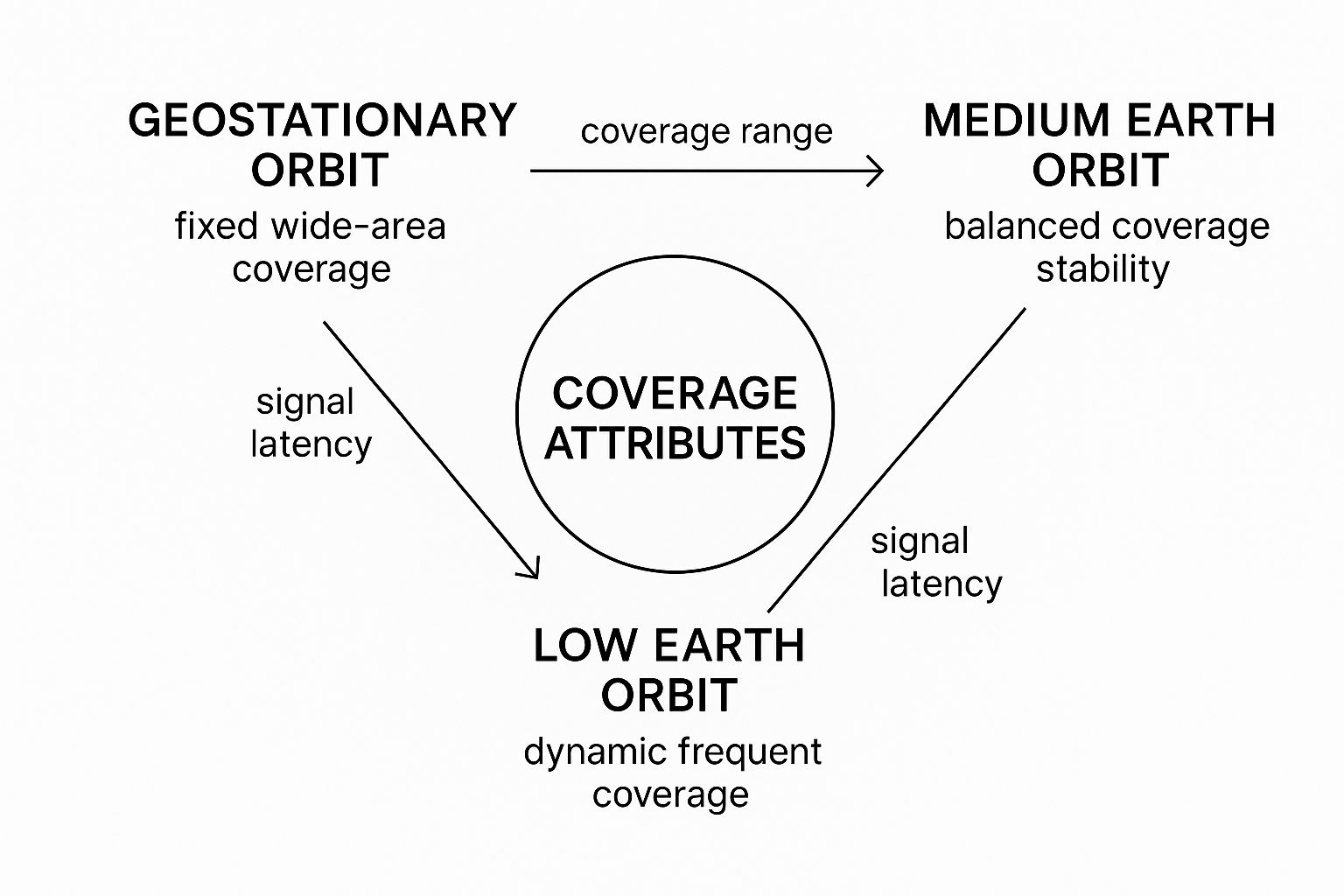
As you can see, GEO satellites offer immense coverage from a single spot, while LEO satellites hug the Earth to prioritise speed and responsiveness.
Geostationary Orbit (GEO)
Picture a single, massive lighthouse positioned way out at sea, its powerful beam lighting up a huge stretch of coastline. That’s the perfect way to think about a Geostationary (GEO) satellite. These orbit at a seriously high altitude—roughly 35,786 kilometres above the equator.
At that exact height, a satellite’s speed perfectly matches the Earth's spin. For us on the ground, this means it looks like it’s fixed in one spot. This clever trick allows a single GEO satellite to provide non-stop coverage over a massive footprint, about one-third of the entire planet.
But there’s a big catch. That massive distance the signal has to travel creates a noticeable delay, what we call high latency. For anything real-time like online gaming or a video call, that lag can be a real pain. Still, GEO is a workhorse for things like TV broadcasting and providing basic internet to extremely remote, fixed locations where latency isn't the main worry. In New Zealand, providers like Optus have historically used GEO satellites to offer services to rural communities.
Low Earth Orbit (LEO)
Now, imagine a huge fleet of small, zippy boats buzzing close to the shore. That’s the concept behind Low Earth Orbit (LEO) satellites. Modern providers like Starlink use this approach, launching thousands of satellites that orbit much, much closer to us—typically between 500 and 2,000 kilometres up.
Because they're so close, the signal travel time is slashed. The result is low latency, giving you a snappy, responsive internet experience that feels a lot like fibre. It's perfect for everything from streaming 4K on a remote farm to running a business from a lifestyle block in the Coromandel.
The real challenge for these LEO constellations is that each satellite zips across the sky incredibly fast. To give you continuous, unbroken coverage, you need a massive, interconnected network of them. Your dish on the ground is constantly and seamlessly handing off the signal from one satellite to the next as they fly overhead.
Medium Earth Orbit (MEO)
Sitting right in the middle, Medium Earth Orbit (MEO) satellites offer a bit of a "best of both worlds" solution. Orbiting somewhere between 2,000 and 35,786 kilometres, they strike a compromise between the huge coverage of GEO and the zippy speeds of LEO.
A single MEO satellite can cover a much larger area than a LEO one, so you don't need as many to get global coverage. While its latency is higher than LEO, it's still way better than GEO. This makes MEO a popular choice for all sorts of commercial and government uses, including in aviation, the maritime industry, and some navigation systems like GPS.
While we're mostly talking about internet satellites here, it's useful to see how this technology is used elsewhere. For another perspective, you might want to check out the importance of GPS satellites in aerial navigation, which is another critical application of MEO satellite tech.
How to Read a Satellite Footprint Map
At first glance, a satellite coverage map can look a bit like a complex weather chart, splashed with strange colours and curving lines. But once you get the hang of their visual language, they become surprisingly simple tools. They'll tell you everything you need to know about your potential connection, right where you are.
This section is your practical guide to decoding them.

Think of it like a topographic map. Instead of showing elevation, a footprint map shows signal strength. The goal is simple: find your spot—whether you're in the Far North or deep in Fiordland—and see what kind of signal quality you can really expect.
Decoding the Colours and Contours
The most obvious things on any footprint map are the ovals or contour lines, which are usually colour-coded. These lines are technically called isopleths, and their job is to connect all the points that receive the same level of signal power.
This signal strength is measured in decibel-watts (dBW). You don't need to get lost in the technical weeds, but the main principle is easy: the higher the dBW number, the stronger and more reliable your signal will be.
A great way to think of it is like a torch beam shining down from the sky. The area right in the centre of the beam is the brightest and most intense. As you move out towards the edges, the light gets dimmer and less focused.
Those colours and lines on the map show you exactly that. They help translate technical data into a simple, practical answer to the big question: "Will I get a good signal right here?"
Finding the Boresight and Edge of Service
On any satellite map, there are two key areas you’ll want to spot. Getting a feel for these will help you quickly figure out the quality of service available at your location.
- Boresight: This is the bullseye. It’s the point on the ground with the most concentrated, powerful signal from the satellite. You'll usually find it at the centre of the innermost contour line, and it represents the absolute peak performance area. If your place in New Zealand falls inside this central zone, you can expect the best possible speeds and reliability.
- Edge of Service: As you move away from that central boresight, the signal strength gradually drops off. The outermost contour line marks what’s known as the "edge of service." Go beyond this line, and the signal might be too weak or patchy for a stable connection, especially if you need it for high-bandwidth activities.
This is vital stuff, especially when choosing the right gear. A location near the boresight might only need a standard-sized dish. But a spot near the edge? You’ll probably need a larger, more powerful antenna to capture enough signal.
Practical Steps for Reading a Map
Right, let's put this into practice. When you’re looking at a provider's coverage map, follow these simple steps to figure out if their service will work for you.
- Locate New Zealand: First things first, find our corner of the world on the map.
- Identify Your Specific Location: Pinpoint as closely as you can where you need the connection—whether it’s a rural property in Hawke's Bay or a remote worksite on the West Coast.
- Check the Contour Lines: See which coloured contour your location falls into. Find the matching dBW value in the map’s key or legend.
- Assess Your Position: Are you close to the boresight for a top-tier signal, or are you nearer the edge, where performance might not be as consistent?
By following this process, you can make a much more informed decision. For an in-depth look at what's available here in NZ, you can explore this guide to the top satellite internet NZ providers in 2025 and see how their coverage stacks up with your needs.
Comparing Satellite Providers Across New Zealand
Navigating the satellite internet scene in New Zealand feels completely different than it did just a few years ago. While a few providers operate here, the conversation for most Kiwis looking for a connection is now dominated by one major player, with other legacy providers serving highly specialised sectors.
If you're after high-speed internet for your home or business, especially in a rural spot, the conversation almost always leads to Starlink. As a Low Earth Orbit (LEO) provider, its massive fleet of small, fast-moving satellites gives it phenomenal coverage across virtually the entire country. A quick look at any Starlink satellite coverage map makes it clear: whether you're on a lifestyle block in the Waikato or a remote station in the Mackenzie Basin, their service is built to reach you.
This wall-to-wall availability is the magic of the LEO constellation model. Old-school Geostationary (GEO) satellites sit in one spot far away, covering a fixed, massive area. Starlink’s approach is more like a blanket of constant connectivity draped over both the North and South Islands, delivering speeds that can genuinely compete with land-based internet.
Starlink and the Direct to Cell Revolution
Starlink's impact isn't just about faster home internet; it's also changing what our mobile phones can do. A massive development for everyday Kiwis is its partnership with telcos like One NZ to roll out 'Direct to Cell' services. This tech essentially turns Starlink satellites into flying cell phone towers.
So what does that actually mean for you? It means your standard, off-the-shelf smartphone can connect directly to a satellite for texting—and eventually voice and data—anytime you're out of range of a normal cell tower.
This is a game-changer for eliminating mobile blackspots all over the country. Think about it:
- For the Tramper: You’re deep in Kahurangi National Park on a multi-day hike and need to send a quick "all good" message. With Direct to Cell, your phone can send that text, no special beacon required.
- For the Rural Worker: A farmer checking fences in a back paddock can report a break straight away, boosting safety and getting things fixed faster.
- For Roadside Emergencies: Breaking down on a lonely stretch of road like the Lewis Pass no longer has to mean you're totally cut off from help.
This technology is fundamentally reshaping what a satellite coverage map means for personal safety and convenience in New Zealand's wildest places.
Satellites have long been the unsung heroes of communication across New Zealand and our surrounding waters, especially given our rugged terrain. Coverage often pushes well beyond the mainland, providing a connection up to 20 kilometres offshore—a crucial lifeline for our marine industries.
This long history has kept our aviation, emergency, and maritime sectors connected for decades. The move to direct-to-cell services is the next evolution of this legacy, pushing reliable communication further than ever before. You can find fascinating insights into this history in official reports, like the one on the investigation of Malaysia Airlines MH370 which referenced Inmarsat satellite data.
Niche Providers for Specialised Needs
While Starlink has the consumer market cornered, it isn't the only name in the game. Traditional GEO satellite providers like Inmarsat, Iridium, and Pivotel are still vital, serving critical niche markets in New Zealand where their unique strengths are irreplaceable. Their services are often built for:
- Maritime Operations: Delivering bulletproof voice and data for shipping vessels and commercial fishing fleets far out at sea.
- Aviation: Guaranteeing constant communication for aircraft on long hauls over remote oceans.
- Emergency Messengers: Powering those handheld devices from brands like Garmin (which uses the Iridium network) and SPOT.
For the Kiwi adventurer heading into the backcountry, a dedicated satellite messenger is often still the smartest choice. These devices are tough, have incredible battery life, and are designed for one job: sending check-in messages or firing off an SOS alert. While a smartphone with Direct to Cell is a fantastic backup, a purpose-built messenger offers a more rugged and reliable solution for extreme environments.
Choosing the right service really comes down to what you need it for. For a detailed breakdown of your options, have a look at our complete guide on satellite internet in New Zealand. Whether you want to stream movies on a remote farm or just need a lifeline on your next Great Walk, there’s a solution out there.
How Satellite IoT Networks Are Connecting Rural NZ
Faster internet in homes is one thing, but satellite technology is also kicking off a quiet but powerful revolution across New Zealand's most vital industries. This is the world of the Internet of Things (IoT), and when you pair it with a solid satellite coverage map, you unlock incredible new ways to boost efficiency and make data-driven decisions right across the motu.
Put simply, IoT gives everyday objects a digital “voice.” Think of small, low-power sensors attached to things like farm gates, water tanks, or even shipping containers. These little devices can gather data—like temperature, location, or fluid levels—and report it back over a network. For years, this only worked if you had cell reception. But now, satellite IoT is rewriting the rulebook.

Satellite IoT networks let these tiny devices phone home from literally anywhere, completely sidestepping the need for cell towers. This is an absolute game-changer for Kiwi industries that operate in our most remote corners.
Real-World Applications Across the Motu
The practical uses for this tech are already changing how businesses operate in what used to be connectivity black spots. This isn’t some far-off concept; it's happening right now, helping people manage their assets and resources in smarter ways.
- Smarter Farming: A farmer in the Canterbury high country can get an instant alert on their phone when a water tank is running low. That saves a long, bumpy trip just to check it manually, leading to better water management and healthier stock.
- Enhanced Conservation: The Department of Conservation (DOC) can deploy smart traps deep in remote Fiordland. These traps report back the moment they’re triggered, making pest control operations far more efficient and effective.
- Streamlined Logistics: A transport company can keep tabs on its valuable assets—whether that’s a truck on the Napier-Taupō road or a container in a rural depot—even when they're miles from any mobile coverage.
Being able to pull data from anywhere gives you a much clearer picture of your operations, which in turn improves safety, cuts costs, and boosts productivity. If you're curious about how satellite fits into the bigger picture of IoT, learning more about enhancing user experience with IoT and its core ideas can be really insightful.
A Nationwide Network Takes Flight
The sheer potential of satellite IoT has sparked major investment in nationwide connectivity. A huge step forward is One NZ's rollout of an IoT satellite network, powered by Starlink's Direct to Cell technology, which is designed to cover 100% of New Zealand.
This new service will bring SMS and data connectivity to IoT devices, specifically targeting the 40% of New Zealand's land mass that currently has no traditional cell service. It uses a clever hybrid model: devices connect to 4G when it’s available but switch seamlessly to satellite the second they move out of range. This opens up massive possibilities for sectors like agriculture and logistics in places that were previously unreachable. Local providers like Pivotel also offer tailored IoT solutions that leverage satellite connectivity for specific industrial needs.
This expansion means an affordable, simple sensor can be placed almost anywhere in the country and be trusted to send back vital information. It’s all about making data collection effortless and universal.
This kind of blanket coverage allows businesses to build reliable monitoring systems without having to worry about connectivity gaps. Whether it’s for farm machinery, environmental sensors, or utility infrastructure, the combination of a comprehensive satellite coverage map and IoT technology is a seriously powerful tool. For those looking into fixed installation options, you might find our guide on Pivotel and Starlink fixed satellite solutions helpful. At the end of the day, this technology gives Kiwi industries the power to make smarter, faster decisions based on real-time data from the field, no matter how remote.
Getting the Most Out of Your Satellite Connection in New Zealand
Picking the right provider and plan is the first major hurdle cleared. But the real make-or-break moment comes when you install the dish. To get that reliable, fast connection you're paying good money for, where you place that dish is everything. It's about more than just pointing it somewhere at the sky; getting a rock-solid signal in New Zealand's varied terrain requires a bit of clever thinking.
The absolute golden rule is to give your dish a clear, unobstructed view of the sky. This is non-negotiable, especially for Kiwis using LEO services like Starlink. The dish is constantly tracking satellites zooming overhead, and even a small, brief obstruction can cause your connection to drop out, usually right in the middle of something important.
Working with the New Zealand Landscape
Our country's geography can throw a few curveballs that might weaken or completely block a satellite signal. Before you drill any holes, you need to have a good look around and see how your immediate environment could cause problems.
Common signal blockers to watch out for in Aotearoa include:
- Tall Native Trees: That gorgeous, towering rimu or stand of tōtara might be a beautiful feature of your property, but for a satellite dish, it's a signal killer. Even a few overhanging branches are enough to cause frustrating, intermittent dropouts.
- Steep Hills and Banks: If your place is tucked into a gully or sits at the bottom of a steep hill, the dish's line of sight can be severely limited. This effectively shrinks the patch of sky it can "see," reducing its ability to connect with passing satellites.
- Nearby Buildings and Structures: Don't forget about the man-made obstacles. Sheds, barns, and even the eaves of your own roof can easily get in the way. You have to check the entire path the dish needs to see.
A good way to think about it is to imagine a massive, invisible cone rising up from your dish. Anything that pokes into that cone is a potential troublemaker. Thankfully, most modern satellite kits come with a smartphone app that uses your camera to scan the sky and help you find these exact obstructions before you commit to a spot.
Dealing with Rain Fade and Classic Kiwi Weather
New Zealand’s weather is nothing if not unpredictable, and a proper downpour can sometimes interfere with satellite signals. This is a well-known phenomenon called rain fade. The dense water droplets in a torrential shower can absorb and scatter the delicate radio waves travelling between your dish and the satellite in space.
But here’s the good news: modern systems are built for this. LEO constellations have a massive advantage here because their satellites are so much closer to Earth. The signal has far less dense, rain-filled atmosphere to travel through, which dramatically lessens the impact compared to the old GEO systems. While an extreme weather bomb might still cause a temporary slowdown, your average rainy day is very unlikely to be an issue for a well-positioned dish.
At the end of the day, taking that extra bit of time to find the perfect mounting spot is the single best investment you can make in your connection's reliability. By carefully checking your line of sight and thinking about our local geography, you can solve problems before they even start and truly enjoy the freedom that satellite internet brings.
Answering Your Top Satellite Internet Questions
Alright, even after getting your head around how satellite coverage maps work, you probably have some real-world questions about what it all means for you here in New Zealand. Let's dig into a few of the most common ones we hear, to clear up any confusion and help you figure out what's right for you.
Is Satellite Internet Really Good Enough for Gaming and 4K Streaming?
This is the big one, and the answer has changed a lot over the years. With the older GEO satellite tech, the massive delay (latency) made online gaming a non-starter and streaming a buffering nightmare. But modern Low Earth Orbit (LEO) constellations like Starlink have completely changed the game for Kiwis.
Because LEO satellites are so much closer to us, latency plummets—often down to 20-40 milliseconds, which is right in line with what you'd expect from fibre. That means you absolutely can enjoy silky-smooth 4K streaming and get competitive in online games, even if you're living way out in the wop-wops. The trick is to go with a LEO provider, as their whole system is built for this kind of heavy lifting.
How Much Does Weather Affect My Satellite Signal?
We all know what a classic Kiwi southerly or a torrential downpour looks like. These can sometimes interfere with your signal in a phenomenon called "rain fade," where heavy rain absorbs and scatters the radio waves on their journey between your dish and the satellite.
But modern systems are built tough to handle it.
- The LEO Advantage: A signal from a LEO satellite has a much shorter trip through the atmosphere, which really dials back the impact of rain fade compared to the old GEO systems.
- System Resilience: While a truly extreme weather bomb might cause a brief slowdown, your average rainy day in New Zealand is very unlikely to knock you offline, especially with a properly installed dish that has a clear line of sight to the sky.
For the vast majority of people in New Zealand, weather-related outages are rare and don't last long. The technology has come so far that it provides a genuinely reliable connection through most of our famously changeable weather.
What Does the Future Hold for Satellite Tech in NZ?
Things are moving incredibly fast. We're seeing satellites getting smaller, more powerful, and a whole lot cheaper to get into orbit. For New Zealand, this all points to one thing: even faster speeds, lower costs, and more clever ways to use the technology.
The move towards 'Direct to Cell' services with providers like One NZ is just the beginning. It won't be long before getting voice calls and basic data on a standard smartphone from anywhere in the country is just normal. This will completely wipe out the last of our mobile blackspots and make life safer for everyone, from trampers deep in the bush to people working in our remote primary industries.
Ready to bridge the connectivity gap for your home, business, or fleet? Mobile Systems Limited offers expert advice and professional installation of leading satellite communication solutions tailored for New Zealand's unique conditions. Explore our satellite internet options today and get a reliable connection, no matter where you are.
Related posts

- August 07, 2025
Your expert guide to the UHF handheld radio in NZ. Learn about legal use, key features, and how to choose...

- August 03, 2025
Discover durable Tait Radios NZ for critical communications. Trust our high-performance radios designed for tough NZ environments. Get yours today!

- August 02, 2025
Discover the best UHF CB radios in New Zealand for 2025. Our guide covers the top models to help you...