Best Handheld GPS NZ 2026: Professional Guide for Rugged Terrain
Imagine standing in a damp gully in the Kaimai Range, watching your GPS coordinates drift while the cloud cover thickens and your smartphone battery drops 20% in ten minutes. For professionals working in New Zealand's backcountry, these technical failures aren't just frustrating; they're a significant operational risk.
Imagine standing in a damp gully in the Kaimai Range, watching your GPS coordinates drift while the cloud cover thickens and your smartphone battery drops 20% in ten minutes. For professionals working in New Zealand's backcountry, these technical failures aren't just frustrating; they're a significant operational risk. You understand that standard consumer devices often lack the antenna sensitivity required to penetrate our dense native bush or the ruggedness to survive a drop onto Central Otago schist.
Finding the best handheld gps nz 2026 requires looking beyond basic navigation to prioritize satellite messaging and extreme durability. This guide provides an expert analysis of the most reliable units for our unique conditions, ensuring you maintain a signal in deep valleys and meet modern Health and Safety standards. We've tested these devices against the 2026 industry benchmarks for battery life in sub-zero temperatures and seamless NZ Topo50 map integration.
We'll examine how specific multi-band GNSS technology overcomes signal errors in steep terrain. You'll also learn which professional-grade hardware offers the best balance of two-way communication and long-term reliability for your team's field operations.
Key Takeaways
- Understand why dedicated hardware outperforms smartphones in New Zealand’s high-humidity environments and remote regions like Fiordland or the Ureweras.
- Discover the best handheld gps nz 2026 options featuring multi-band GNSS for pinpoint accuracy in deep valleys and steep alpine terrain.
- Learn how to select specific GPS models tailored for industry requirements, from canopy-penetrating forestry tools to two-way communication devices for adventure tourism.
- Compare professional-grade models like the Garmin GPSMAP 67i and Montana 700i to determine which hardware best suits your specific field operations.
- Evaluate the benefits of professional NZ-based procurement and custom firmware configuration to ensure your business fleet is reliable and field-ready.
Why Dedicated Handheld GPS Units are Essential in New Zealand’s Backcountry
New Zealand's terrain is famously unforgiving. Whether you're navigating the dense canopy of the Ureweras or the granite peaks of Fiordland, relying on consumer-grade technology is a significant risk. While smartphones offer convenience, they aren't the best handheld gps nz 2026 for professional or remote use. A dedicated unit utilizes the Global Positioning System (GPS) with high-gain antennas that maintain a signal lock where phones often fail.
To better understand how these devices compare in the current market, watch this helpful video:
Ruggedized hardware is built to withstand high humidity and unpredictable alpine weather. Most professional units feature IPX7 waterproof ratings and shock resistance that exceeds military standards. These devices handle the grit of a West Coast riverbed or the freezing sleet of the Southern Alps without internal corrosion or screen failure. It's about having a tool designed for the environment, not a multi-purpose gadget that's vulnerable to the elements.
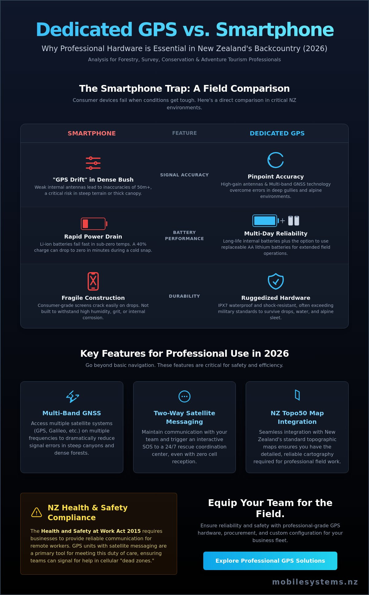
The "Smartphone Trap" in NZ Conditions
Lithium-ion batteries in smartphones drain rapidly when temperatures drop below freezing in the Southern Alps. You'll often find a phone battery jumping from 40% to zero in minutes during a cold snap. Consumer screens are also prone to cracking when exposed to grit or dropped on rocky tracks. Most importantly, phones lack external antennas. This leads to "GPS drift" in heavy bush, where your reported position can be off by 50 metres or more, making it the wrong choice for the best handheld gps nz 2026 in critical situations.
Regulatory and Safety Compliance for NZ Businesses
Under the NZ Health and Safety at Work Act 2015, businesses have a duty of care to provide reliable communication for remote workers. Handheld GPS units with integrated satellite messaging serve as a primary safety tool for forestry, survey, and conservation teams. They ensure workers can signal for help in "dead zones" where cellular coverage is non-existent. For teams that require broader communication strategies, this complete guide for satellite phones in NZ highlights how to maintain safety in total isolation.
Battery choice is another critical factor for multi-day South Island treks. While internal lithium-ion batteries are common, many professionals prefer units that accept AA batteries. You can't easily recharge a device in the middle of Kahurangi National Park, but you can swap in a fresh set of lithium AAs in seconds. This flexibility ensures your navigation remains active regardless of how many days you're away from a power grid. A tailored assessment of your specific route often prevents these types of costly logistical mistakes.
Key Features to Evaluate in 2026: Beyond Basic Navigation
Selecting the best handheld gps nz 2026 requires looking past basic waypoint marking. Modern hardware now integrates high-precision satellite receivers with global communication tools. This evolution ensures safety and precision when working in remote environments like the Southern Alps or the dense bush of the Urewera.
Reliability in the field depends on how a device handles signal interference and power management. In 2026, the gap between consumer-grade tools and professional instruments has widened, specifically regarding signal processing and battery chemistry. Professional users must prioritise hardware that maintains a lock in deep cover and provides legible data under the harsh New Zealand sun.
Understanding Multi-Band GNSS for NZ Terrain
Multi-band GNSS refers to a device's ability to track multiple signals from a single satellite across different frequency bands. Older units relied solely on the L1 signal, which is prone to atmospheric interference. Modern professional units utilize both L1 and L5 frequencies to cross-reference data and eliminate timing errors.
This technology is critical for New Zealand's geography. It solves "multipath" errors caused by signals bouncing off schist cliffs or steep canyon walls before reaching the antenna. By comparing the two signals, the processor identifies and ignores the reflected "noise" that would otherwise cause a position jump of 30 metres or more. Multi-band GNSS is the essential 2026 standard for sub-3-metre accuracy.
Satellite Messaging and InReach Integration
The industry has shifted from "navigation only" devices to integrated communication hubs. While a traditional Personal Locator Beacon (PLB) is a vital emergency tool, it's a "silent" device that doesn't allow for status updates or coordinated rescues. Modern handhelds often include Iridium-based two-way messaging.
The Iridium constellation uses 66 cross-linked satellites to provide 100% pole-to-pole coverage. This is superior for NZ users compared to regional satellite networks that may have "dead zones" in southern latitudes. According to 2026 handheld GPS reviews, the ability to text a base station or receive weather updates directly on the map screen is now a baseline requirement for remote field work.
Map Compatibility and Display Tech
Digital maps are only as good as their local accuracy. Professional users in New Zealand require devices that fully integrate NZ Topo50 data. This ensures that 1:50,000 scale contour lines, hut locations, and river crossings align perfectly with the physical world. Relying on generic global base maps often leads to dangerous errors in elevation and track placement.
Display technology also dictates field performance. While high-resolution touchscreens look impressive in an office, they often fail in wet conditions or drain batteries within hours. Transflective screens are the preferred choice for the best handheld gps nz 2026. These displays use ambient sunlight to illuminate the screen, becoming clearer as the sun gets brighter while significantly extending battery life.
Choosing the right hardware configuration depends heavily on your specific operational environment. A tailored assessment of your team's terrain requirements often prevents costly mistakes. You can explore the latest professional GPS and satellite communication tools to find a solution that fits your workflow.
Top-Rated Handheld GPS Models for the NZ Market in 2026
Selecting the best handheld gps nz 2026 requires balancing signal reliability with the demands of New Zealand's unique geography. Our terrain often features deep valleys and dense canopy cover that can challenge standard consumer devices. Professional grade units must maintain a lock on multiple satellite constellations to ensure safety and data accuracy.
The Professional Standard: Garmin GPSMAP 67i
The GPSMAP 67i remains the benchmark for field operations in the Southern Alps and remote bush. It features dedicated physical buttons, which are essential for technicians and search teams operating with heavy gloves in wet or freezing conditions. Unlike touchscreen-only units, these tactile controls ensure precise navigation when the weather turns.
This model offers up to 180 hours of battery life in standard GPS tracking mode, and can extend to 425 hours in expedition mode. It integrates full Iridium satellite technology, allowing for two-way messaging and SOS triggers where cellular networks fail. View our GPS collection for current availability and detailed technical specifications.
Versatility for Fleet Use: Garmin Montana 700i
The Montana 700i is designed for professionals who transition frequently between vehicles and foot patrols. Its 5-inch sunlight-readable touchscreen provides the clarity needed to interpret complex NZ Topo50 map data quickly. This is particularly useful for identifying property boundaries or specific topographical features in high-pressure situations.
Engineers and agricultural contractors benefit from rugged mounting options for 4WDs, side-by-sides, and quad bikes. This unit bridges the gap between dedicated vehicle systems and individual navigation, providing high-resolution data that supports safety protocols in the field. It's a robust tool for those who need a larger visual reference for complex mapping tasks.
Alternative Solutions: eTrex Solar and inReach Mini 2
For long-duration field work where charging isn't an option, the Garmin eTrex Solar provides virtually infinite battery life when used in 75,000 lux conditions. It's a budget-conscious, reliable choice for ecological surveys or forestry work where simple waypoint tracking is the priority over complex messaging.
When weight is the primary constraint for back-country operations, the Garmin inReach Mini 2 offers a compact solution. At just 100 grams, it provides the same Iridium satellite messaging and SOS capabilities as larger units without the bulk. It's the preferred companion for solo workers who require a reliable safety tether back to base but don't need a large, power-hungry map display. Choosing the best handheld gps nz 2026 ultimately depends on whether your priority is screen real estate, battery longevity, or total portability.
Selecting the Right GPS for Your Specific Industry and Safety Needs
Choosing the best handheld gps nz 2026 requires more than comparing screen sizes or battery life. Professional operations in New Zealand demand hardware tailored to specific environmental challenges, from the dense moisture of West Coast podocarp forests to the high-altitude exposure of the Southern Alps. Reliability in these zones isn't just a convenience; it's a core safety requirement for lone workers and group leaders.
For environmental surveying, the priority shifts toward data integrity. High-accuracy waypoint averaging is essential when recording rare flora or mapping geohazards. In these scenarios, a device must support multi-band GNSS to ensure sub-3-meter accuracy even when the horizon is partially obscured by steep ridgelines or deep gullies.
Search and Rescue (SAR) operations face unique technical hurdles. Gear must be compatible with local radio frequencies and P25 digital systems to ensure seamless coordination. A GPS that causes electromagnetic interference with a team's primary communication tool is a liability. Professionals look for shielded units that maintain high performance without compromising the clarity of critical radio traffic.
Forestry and Heavy Industry Requirements
Operations in the Kaingaroa Forest or rugged silviculture blocks require devices with external Quad Helix antennas. These antennas, standard on the Garmin GPSMAP series, provide superior signal acquisition under heavy pine canopy where internal patch antennas often struggle. Maintaining a consistent signal is vital for "breadcrumb" tracking, which allows managers to monitor lone worker progress and verify that high-risk areas have been cleared.
Reliable tracking works best when paired with robust voice comms. For integrated safety solutions, many crews combine their GPS units with professional two-way radio systems to ensure redundancy. If a worker stops moving, the breadcrumb trail gives rescuers a precise starting point, while the radio provides immediate voice contact.
Tourism and Guiding Best Practices
Adventure tourism operators use GPS technology to bridge the gap between field groups and base operations. Real-time location updates via satellite messaging allow guides to share progress without needing cellular coverage. Pre-loading high-resolution NZ DOC track maps ensures that even if a trail is obscured by windfall or snow, the guide can keep the group on the safest path.
Maritime-adjacent guiding, such as sea kayaking or coastal trekking, introduces the need for waterproof, buoyant equipment. Integrating satellite navigation with portable communication tools ensures that guides can reach help on both land and sea frequencies. This layered approach to safety is the standard for the best handheld gps nz 2026 in the commercial guiding sector.
A tailored assessment often prevents costly mistakes when equipping a professional team. Contact Mobile Systems to discuss your specific industry requirements.
Professional Support and Procurement for NZ Business Fleets
Procuring the best handheld gps nz 2026 for a commercial fleet requires more than a simple retail transaction. Businesses operating in forestry, agriculture, or search and rescue need hardware that's ready for immediate deployment. While offshore retail sites might offer lower initial prices, they often lack the localized configuration required for rugged New Zealand conditions.
Mobile Systems provides a critical bridge between generic hardware and site-ready tools. We handle the complexities of custom map loading and firmware synchronization across large teams. This ensures every staff member uses the same data sets, reducing navigational errors and improving safety protocols in remote areas like the Kaimai Ranges or the Southern Alps.
It demands the integration of GPS units into broader communication ecosystems. We specialize in linking handheld devices with existing UHF, VHF, or satellite networks. This unified approach means your team stays connected even when they're well beyond cellular coverage, utilizing 2026-standard satellite messaging and SOS features.
The Mobile Systems Advantage
Our expertise lies in designing integrated systems that prioritize reliability. We provide New Zealand based warranties, which means your equipment doesn't sit in an international shipping queue when it needs servicing. Our technical team performs troubleshooting and firmware updates locally, minimizing downtime for your field operations.
A tailored assessment often prevents costly procurement mistakes. We analyze your specific terrain challenges and communication gaps before recommending a hardware suite. This professional oversight ensures your investment in the best handheld gps nz 2026 provides a measurable return through improved operational efficiency and worker safety.
Contact and Consultation
For organizations requiring bulk pricing or specialized fleet configurations, our team offers comprehensive support. We invite business owners and fleet managers to visit our Mount Maunganui base for physical equipment inspections and hands-on demonstrations of the latest GPS technology.
To discuss your specific requirements or request a quote for your team, please visit the Mobile Systems Contact Page. Whether you need five units or fifty, we provide the technical depth and local support necessary to keep your fleet moving safely across New Zealand's most demanding landscapes.
Securing Your Backcountry Operations for 2026
Navigation in New Zealand's dense bush and alpine regions requires more than a consumer-grade smartphone. Professional teams need hardware that withstands high annual rainfall and provides reliable Iridium satellite messaging where cellular networks fail. Selecting the best handheld gps nz 2026 ensures your staff remain connected and safe, regardless of the terrain.
Mobile Systems Limited has specialized in ruggedized commercial communication since 2000. As official suppliers of Garmin and Iridium technology, we provide the technical expertise required to manage complex fleet deployments across diverse industries. Our NZ-based technical support and mobile servicing teams ensure your equipment stays operational in the field. It's a level of localized support that prevents costly downtime and keeps your staff safe in remote locations.
Request a professional GPS fleet assessment from Mobile Systems to ensure your team is equipped with the most reliable technology for New Zealand conditions.
Proper planning today protects your workforce tomorrow.
Frequently Asked Questions
Is a handheld GPS better than a smartphone app for NZ tramping?
A dedicated handheld GPS is significantly more reliable than a smartphone for New Zealand tramping due to its rugged construction and superior antenna. Most professional units feature IPX7 waterproof ratings and are designed to withstand drops on rocky terrain that would shatter a standard phone screen. Handheld devices also use dedicated GPS, GLONASS, and Galileo sensors that maintain a lock in deep bush where smartphones often lose signal.
Battery management is another critical factor for safety in the backcountry. Smartphones typically struggle with battery depletion in cold alpine environments, whereas a handheld GPS can run for 35 to 180 hours depending on the model. Mobile Systems Limited recommends dedicated units for any multi-day expedition where communication and navigation are safety-critical. Relying on a phone as a primary device often leads to failure when conditions deteriorate.
Do I need a subscription to use the GPS features on a Garmin inReach?
You don't need a subscription to use the core GPS navigation, waypoint marking, or mapping features on a Garmin inReach device. The unit will function as a standard high-performance navigator right out of the box. You can view your position on pre-loaded maps and track your progress without any ongoing monthly costs or activation fees.
A paid subscription is only required if you want to use the Iridium satellite network for two-way messaging, live tracking, or SOS emergency services. For professional users in New Zealand, having an active plan provides an essential safety layer. Mobile Systems Limited can help you select a plan that balances cost with the specific communication needs of your team or project.
What is the most accurate handheld GPS for New Zealand's steep terrain in 2026?
The most accurate devices for the best handheld gps nz 2026 are those equipped with multi-band GNSS technology, such as the Garmin GPSMAP 67 series. These units access multiple satellite frequencies simultaneously, which significantly reduces signal interference caused by steep canyon walls or heavy forest canopy. This technology provides a position accuracy of within 2 to 3 metres even in challenging environments.
Older single-band units often suffer from "multipath error" where signals bounce off cliffs in the Southern Alps, leading to drifted location data. By utilizing the L1 and L5 frequencies, the latest professional models ensure your coordinates remain precise. This level of accuracy is vital for search and rescue operations or precision land surveying where every metre counts toward a successful outcome.
Can I load NZ Topo50 maps onto any handheld GPS unit?
Compatibility with NZ Topo50 maps depends entirely on the device's operating system and storage capacity. Most modern Garmin handhelds support official TOPO New Zealand and Australia maps or open-source .img files derived from Land Information New Zealand (LINZ) data. It's essential to verify that your chosen unit has a microSD card slot or sufficient internal memory to handle high-resolution topographic data.
Loading these maps allows you to see 20-metre contour lines, huts, tracks, and river crossings directly on your screen. At Mobile Systems Limited, we ensure that the units we provide are configured with the most relevant local mapping data. Using outdated or low-resolution maps is a common mistake that can lead to navigation errors in New Zealand's complex river systems and ridgelines.
How long do batteries typically last in a handheld GPS in alpine conditions?
Battery life in alpine conditions typically ranges from 16 hours on older AA-powered units to over 200 hours on modern integrated lithium-ion models. Cold temperatures in ranges like the Tararuas or the Kawekas can reduce standard alkaline battery performance by up to 50 percent. For this reason, professional users should always use lithium AA batteries or internal rechargeable packs designed for extreme temperatures.
To maximize your runtime, you can adjust settings such as screen brightness and the track log recording interval. Using "Expedition Mode" on newer devices allows the unit to stay powered for weeks by powering down the screen and only waking up periodically to log a point. Mobile Systems Limited advises carrying a portable power bank or spare lithium cells for any trip lasting longer than two days.
What is the difference between a PLB and a handheld GPS with satellite messaging?
A Personal Locator Beacon (PLB) is a dedicated emergency device that sends a powerful 406 MHz signal directly to search and rescue satellites. It has a battery life of 5 to 7 years and requires no ongoing subscription, but it only offers one-way communication. Once you trigger it, you can't provide details about your situation or receive confirmation that help is on the way.
A handheld GPS with satellite messaging, like an inReach or Montana, uses the commercial Iridium network for two-way communication. This allows you to text emergency services to describe specific injuries or coordinate a non-emergency pickup. While these devices require regular charging and a monthly subscription, the ability to communicate back and forth is often preferred by professional field teams for logistical coordination.
Are touchscreens or buttons better for professional use in NZ?
Physical buttons are generally the better choice for professional use in New Zealand's unpredictable weather. Touchscreens often struggle with "phantom touches" when covered in raindrops and can be difficult to operate while wearing thick gloves in alpine zones. Buttons provide tactile feedback that ensures you can navigate menus accurately even when your hands are cold or wet.
While modern touchscreens have improved, many field workers find that a button-based interface like the one on the GPSMAP series is more durable over long-term use. Buttons don't crack as easily as glass screens and remain functional in mud and grit. If your work involves frequent data entry, a touchscreen might be faster, but for pure reliability, the traditional button layout is the industry standard.
Can I use my handheld GPS to communicate with local VHF radios?
You cannot use a standard handheld GPS to communicate directly with VHF radios because they operate on completely different frequencies. GPS units receive high-frequency signals from satellites at approximately 1575 MHz, while local VHF radios typically operate between 136 and 174 MHz. These two technologies are not cross-compatible for voice or data transmission.
To bridge this gap, some professionals use integrated devices or carry both a GPS for navigation and a separate rugged VHF radio for team communication. Mobile Systems Limited specializes in integrated communication solutions that ensure your team stays connected across various platforms. A tailored assessment of your specific site requirements often prevents costly mistakes when investing in new hardware for remote operations.
Related posts

- May 24, 2026
Our expert Starlink review NZ looks at speed, pricing, and reliability for business, farm, and maritime use. See if it's...

- May 23, 2026
Approximately 40% of New Zealand's landmass remains outside the reach of traditional mobile networks. For professional teams operating in remote...

- May 14, 2026
A complete guide to Starlink setting up for NZ businesses. Learn pro tips on site survey, mounting, network integration, and...